Rates & availability change: Sumba Helicopter Tours is an independent travel and concierge service that connects you to vetted drivers and partners — we are not a government body. All prices are RANGES (IDR/USD) flagged with the date last verified and separate the base service from fuel, parking, and extras; confirm current rates, vehicle, and availability before booking. Bali charges an international tourist levy of IDR 150,000 per person. If you proceed with a partner we introduce, they may pay us a referral fee at no extra cost to you.
Sumba villages are traditional hilltop and coastal communities defined by soaring peaked roofs, stone megaliths and living Marapu rituals. Seen from the air, these villages reveal their full geometry: concentric stone tombs, clan houses aligned to the wind, and the way each settlement is anchored to the savannah and sea.
What Makes Sumba’s Traditional Villages Unique?
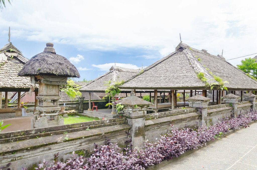
Sumba’s traditional villages are among Indonesia’s most distinctive living cultural landscapes. Rather than isolated houses, you see compact clusters of tall-roofed clan homes (uma), arranged around megalithic tombs and ceremonial plazas. This pattern appears again and again across the island – from Ratenggaro on the coast to Praijing village in the highlands – yet each place is shaped by its own clan history, river valley, and hilltop.
Several elements define Sumba’s megalithic villages:
- High, peaked roofs (uma marapu) – thatched towers often up to 15–25 metres, symbolically connecting the living to ancestral spirits.
- Stone megaliths and tombs – carved slabs and dolmen-like platforms, still used for major clan burials.
- Central plazas – open stone-lined spaces for rituals, harvest ceremonies, and Pasola-related gatherings.
- Defensive siting – many villages crown ridges or promontories, originally chosen for visibility and protection.
From ground level, you experience the texture of stone, wood and thatch. From the air, you see something else: how each village sits in dialogue with its landscape – guarding a river mouth, watching over a bay, or perched above a quilt of dry savannah and forest.
Why See Sumba Villages From the Air?
Helicopter access does not replace a respectful village visit on foot. It adds a different dimension.
- Understand the full layout
Many guests are surprised, on the ground, by how close the tombs are to homes, or how complex the street pattern is. A short aerial orbit reveals the entire village plan in seconds – where the clans gather, how paths weave in, where new houses are emerging at the edges. - Context within the wider landscape
Sumba’s villages were never meant to be viewed in isolation. From the air, Ratenggaro’s stone tombs line up with the surf of the river mouth; Praijing’s houses form a spine along a ridge with multiple valleys dropping away on both sides. You see terraces, river systems and savannah all at once. - Access to remote regions
Some of the most traditional settlements lie beyond paved roads. A helicopter route lets you overfly them with minimal ground impact, then land at selected villages reached via existing tracks, arranged through local partners. - Gentler footprint than overland loops
Done well, a short 25–45 minute aerial circuit often replaces several hours of driving and motorbiking through small roads. That means fewer vehicle convoys passing the same houses, and more time for one or two carefully arranged village visits.
We do not sell helicopter flights as “cultural safaris” that replace genuine encounters. We help you use the air strategically – to see patterns, avoid over-touristed hours, and arrive at the right villages at the right time.
Key Villages to View From the Air
Ratenggaro: Megaliths at the Edge of the Sea
Ratenggaro lies on Sumba’s southwest coast where a river meets the Indian Ocean. From the air, it is one of the most graphic village silhouettes on the island: a compact cluster of towering roofs, stone tombs extending almost to the cliff edge, and long lines of surf wrapping around the bay.
From above you notice:
- The perfect alignment of stone graves parallel to the coastline.
- The sharp contrast between pale tomb slabs and dark thatch.
- The way new houses are creeping inland, while the original core hugs the headland.
An aerial approach typically traces the curve of the coast, then orbits inland so that the village is framed against the sea. With doors-on flying, photography is through the window; doors-off, where available and approved by the operator, allows unobstructed shooting but requires strict harnessing and operator consent.
Most itineraries pair Ratenggaro with nearby beaches, headlands and waterfalls of Southwest Sumba, giving you varied scenery in a single sortie.
Praijing Village: Hilltop Geometry in Central Sumba
Praijing village, just inland from Waikabubak, is a classic example of Sumba megalithic villages clinging to a ridge. On the ground, boardwalks and viewpoints let you see the roofs up close. From the air, the layout is cleaner and more striking.
You see:
- A narrow, elongated village spine following the ridge crest.
- Ring-like arrangements of tombs on each “terrace” level.
- The patchwork of small gardens, secondary forest and savannah dropping away on both sides.
Helicopter routes can fly along the valley first, then rise to ridge height for an orbit if conditions and airspace are suitable. It is a beautiful way to understand why ancestral Sumbanese chose these particular hilltops: wide views, natural drainage, and the psychological sense of living closer to the sky.
Other Traditional Villages on Typical Routes
Exact routing depends on where you are staying and on operator approvals, but several regions tend to feature in village-focused aerial scouting:
- West Sumba highland villages
Around Waikabubak and further inland lie multiple hilltop communities with classic peaked roofs and stone tombs. From the air, they appear as islands of thatch on fingers of high ground, separated by shallow ravines and rice paddies. - Southwest coastal villages
In the broader Ratenggaro area, other communities sit back from the cliffs, overlooking estuaries and lagoons. They are rarely named in guidebooks but are clearly visible from a safe overflight altitude as you follow the coast. - East Sumba savannah hamlets
Eastward, village clusters become sparser, set in open savannah. Here, the contrast between wide, almost empty plains and the tight, vertical punctuation of roofs is especially clear from above.
For privacy and safety, pilots maintain respectful lateral and vertical separation. The goal is to see the overall pattern, not hover directly above households.
Suggested Helicopter Itineraries for Village Lovers
The following are conceptual examples built from actual flying patterns around Sumba. Final flight paths, durations and landing options are set by the operator and pilot based on weather, airspace and safety.
1. Southwest Sumba Coastal & Ratenggaro Focus
Who it suits: Guests based in the southwest (for example near Wanokaka or the popular surf and beach resorts) with limited time who want a strong visual of Ratenggaro and the megalithic coast.
Typical elements (approx. 30–45 minutes in the air):
- Coastal ascent along cliffs and river mouths.
- One or two orbits off Ratenggaro to see the village against the sea.
- Continuation along beaches, headlands and estuaries with scattered villages visible inland.
Some operators may, on request, incorporate a landing at or near an accessible coastal point, from which your ground guide drives you to a pre-arranged village visit. Ground arrangements are typically organised separately via your resort or DMC; we help coordinate the aerial side.
2. Central Highlands & Praijing Village Circuit
Who it suits: Guests interested in landscape context – seeing how villages align with ridges, rivers and rice fields.
Typical elements (approx. 40–60 minutes in the air):
- Departure from a central or western helipad.
- Low–medium-level flying along river valleys and terraced fields.
- Overflight of Praijing village to appreciate its ridge-line geometry.
- Scanning multiple other hilltop clusters before returning via a different valley.
Some itineraries combine this circuit with a waterfall flyover or a landing near a known hiking trail, enabling you to walk into a village area after seeing the broader panorama from above.
3. Full “Megalithic Sumba” Aerial Overview
Who it suits: HNW travellers seeking a deep first-day orientation: a sense of how Sumba’s megalithic villages dot the island from coast to interior.
Typical elements (approx. 75–110 minutes in the air, possibly with a fuel or ground stop):
- Coastal run taking in Ratenggaro and other coastal communities.
- Turn inland to the central highlands, including Praijing and neighbouring ridges.
- Optional extension eastward to appreciate savannah villages and broader dryness gradients across the island.
This kind of itinerary is particularly effective as a “big picture” half-day: see everything from the air first, then spend the following days returning by road, more slowly and selectively, to a few villages that resonate with you.
For ideas tailored to your base resort and trip length, you can plan your trip with our team via email or WhatsApp; we’ll outline realistic options with vetted operators.
Prices: What to Expect for Village-Focused Helicopter Flights
We are not an aviation authority and we do not operate aircraft ourselves. We work with vetted helicopter operators who set their own aircraft types, safety standards and pricing.
Helicopter costs across Indonesia can shift with fuel, maintenance and seasonal demand. The ranges below are indicative only and based on recent market checks for light and medium helicopters operating charter-style flights in eastern Indonesia, last verified June 2026.
| Experience Type | Typical Air Time | Indicative Charter Range (USD)* | Notes |
|---|---|---|---|
| Short village & coast scenic (e.g., Ratenggaro focus) | 25–35 minutes | Approx. $1,600–$2,400 | Usually ex one base; often suitable for 2–4 guests depending on aircraft and weight. |
| Central highland & Praijing circuit | 40–60 minutes | Approx. $2,200–$3,400 | May include additional village clusters or a waterfall overflight. |
| Extended “Megalithic Sumba” overview | 75–110 minutes | Approx. $3,800–$5,800 | Potential refuelling stop; route complexity and landing requests affect final quote. |
| Point-to-point helicopter transfer with village views en route | 30–90 minutes (route-dependent) | Approx. $1,800–$5,000 | Transfer pricing varies by distance between resort, airport and any intermediate detours. |
*All ranges are indicative, for private charter of the whole aircraft, last verified June 2026. Exact quotes are provided by the operator for your specific date, route, aircraft and passenger/weight details.
Several factors influence price:
- Aircraft type & capacity – lighter helicopters cost less per hour but carry fewer passengers or luggage.
- Starting helipad – positioning flights to reach your resort or departure point are often billable.
- Route design – adding extra orbits, village clusters, or remote landings can extend flight time.
- Season & availability – peak holiday periods or major events can tighten supply.
We will always present pricing as clearly as possible before you commit, and the operator will confirm final terms. No one can pay to change what we publish; if you proceed with our partner they may pay us a referral fee at no extra cost to you.
Helicopter vs. Road: How Do Village Experiences Compare?
- Perspective
- Helicopter: macro view of village layout, landscape patterns, position along ridges and coasts. Road: intimate view of daily life, textures, conversations.
- Time efficiency
- Helicopter: several regions in an hour of flying. Road: multiple hours of driving for each cluster, often over rough surfaces.
- Physical demand
- Helicopter: minimal walking required unless you add ground visits. Road: heat, dust and uphill paths to reach hilltop villages.
- Cultural depth
- Helicopter: visual understanding, photography, orientation. Road: actual meetings with elders and families, guided explanations of Marapu traditions.
- Environmental and social footprint
- Helicopter: concentrated noise impact along defined routes, fewer village pass-throughs. Road: more vehicles on rural tracks, but no aviation fuel use.
The most rewarding approach, for most guests, is hybrid: use helicopter time early in your stay to see Ratenggaro, Praijing and other Sumba villages from above, then choose two or three to visit on foot with a thoughtful local guide.
Respectful Cultural Context: Flying Over Living Communities
Sumba’s villages are not open-air museums. They are working communities, many of which still follow Marapu belief systems, with ancestor veneration, sacred stones and ritual calendars that govern daily life.
When seeing villages from the air and on the ground, several principles matter:
- Privacy and altitude
Responsible operators maintain altitudes and lateral separation that allow a clear view of the village layout without hovering at roof level. The goal is to observe patterns, not to peer into courtyards. - Photography ethics
From the air, wide shots of roofs and tombs are generally acceptable; highly zoomed images of individuals in their homes are best avoided. On the ground, always ask your guide when and how to request photo permission. - Marapu and megaliths
The stone tombs you see clearly from the air are not relics; many are part of an unbroken centuries-long tradition of megalithic burials. On foot, you may pass active or recently used sites – step carefully and follow your guide’s lead. - Economic respect
Village visits should be arranged in partnership with local leaders, with clear contributions (fees, purchases, or program support) agreed in advance. Helicopter access should not shortcut that process; it simply changes how you arrive.
We work only with partners who show consistent respect for communities and are open to feedback from local leaders as tourism evolves.
Weather, Safety & Realistic Expectations
Sumba’s dry season generally runs from around May to October, bringing clearer skies and calmer air, while the wetter months can see more cloud build-up and showers. That said, micro-weather around ridges and coasts can change quickly in any month.
A few realities to keep in mind:
- Flights are always weather-dependent
Even in peak season, low clouds, strong winds, haze or rain can delay, shorten or cancel flights. No reputable operator will guarantee a specific route or precise orbit over a given village in advance. - Route flexibility is essential
If a planned loop over Ratenggaro is blocked by coastal weather, the pilot may route inland instead, prioritising valleys and highlands where visibility is better. - Safety-first decision-making
Pilots make the final call on whether to depart, where to orbit, and how low or close to fly within regulations and company procedures. This may override proposed photography angles or sequences. - Door-off flying is not guaranteed
Some helicopters and operators allow doors-off photography in suitable conditions, others do not. Even where technically possible, weather, weight and safety assessments may restrict this option on the day.
If you have a tight schedule, it can be wise to keep one “buffer” morning or afternoon open, so that your operator has more flexibility to pick the best weather window during your stay.
Planning Your Sumba Villages Aerial Experience
Because Sumba’s tourism infrastructure is still relatively young compared to Bali or Java, planning early pays off – especially for private helicopter arrangements.
Steps we typically follow with guests:
- Clarify your base and dates
Tell us where you will sleep on each night (airport hotels, beach resorts, private villas). This shapes which helipads and routings are realistic. - Define your priorities
Is your focus primarily Ratenggaro and the southwest, Praijing and central highlands, or a broad overview of Sumba megalithic villages? Do you want a quick scenic, or a half-day experience with a ground visit? - Discuss timing and light
Morning departures often give calmer air and softer light; late-afternoon can be dramatic but may face more convective cloud and time pressure around sunset. - Coordinate with your ground guide
For hybrid days that mix helicopter and road visits, we help synchronise pickup and drop-off points so your driver and village guide know exactly where and when to meet you. - Review safety & weight details
Operators will ask for passenger weights, approximate luggage, and any mobility issues in advance to assign a suitable aircraft and seating plan.
If you share your dates, group size and interests, we can sketch a realistic outline by email and WhatsApp. Use plan your trip to start that conversation; nothing is confirmed until you approve the final routing and the operator issues a booking.
What to Expect During the Flight
Although each operator has its own exact protocols, a Sumba villages helicopter experience often follows a similar flow:
Before Departure
- Check-in and briefing – overview of the route plan, approximate timings and current weather conditions.
- Safety procedures – seatbelts, headset use, door operation, and what to do during embarkation and disembarkation.
- Camera prep – confirm whether windows can be opened, what is allowed loose in the cabin, and how to secure lenses or small bags.
In the Air
- Climb and transit – initially you gain altitude to clear terrain and reach cruising level. Early views often include rivers, roads and small hamlets.
- First village overflight – as the pilot calls out the target, you may do a wide pass first, then a gentler orbit if conditions allow, so that both sides of the aircraft have viewing time.
- Adjustments – pilots sometimes extend or shorten an orbit based on turbulence, cloud layers or airspace considerations.
After Landing
- Debrief – a short recap of what you saw, and which areas might be best to revisit by road.
- Transfer onward – pre-arranged vehicle pickup for either a village ground visit, a return to your resort, or a direct transfer to another part of Sumba.
Most guests describe these flights less in terms of adrenaline, more as a serene, almost meditative glide above savannah, roofs and stones – punctuated by moments where a village suddenly reveals its full shape in a way no road could ever show.
Working With an Independent Specialist
Sumba Helicopter Tours exists for one purpose: to help you think clearly about what is possible in the air over Sumba and to connect you with operators who can deliver that safely and thoughtfully.
We are not an airline, not a resort, and not a government body. We stay independent so we can:
- Compare multiple operators’ capacities and likely availability for your dates.
- Sanity-check routes against actual geography, not just marketing maps.
- Be candid when a request (for example, a very low orbit over a specific village at a specific time) is improbable or unwise.
No one can pay to change what we publish; if you proceed with our partner they may pay us a referral fee at no extra cost to you. Our role is to align your expectations with Sumba’s realities, then step back so the pilot, your guide and the island itself can speak.
To start designing an aerial perspective on Sumba villages that matches your schedule and interests, you can plan your trip with us – we respond by email and WhatsApp, and we stay honest if the best answer for a given day is, “Save this flight for your next visit.”
FAQs on Seeing Sumba Villages by Helicopter
Can I land directly in Ratenggaro or Praijing village?
Direct landings inside village plazas or among tombs are not appropriate and, in practice, not offered. Landings, where available, are usually at pre-assessed clearings, helipads or nearby open areas away from homes and megaliths. From there, access to Ratenggaro, Praijing or other Sumba villages is arranged via road or walking paths with a local guide.
How far in advance should I book a village-focused helicopter flight?
For peak seasons and multi-stop itineraries, 4–8 weeks’ notice is highly advisable. Helicopter availability on Sumba is limited, and operators juggle maintenance, positioning and weather windows. Shorter notice is sometimes possible for simple routes, but flexibility on date and time becomes more important.
Is aerial photography of Sumba villages allowed?
Wide, contextual photography from the air is generally acceptable, and many guests capture village layouts, roofs and landscapes. However, regulations, operator policies and local sensitivities still apply. High-powered telephoto shots of individuals or highly private moments are best avoided. Your pilot will advise on any specific restrictions relevant at the time of your flight.
Will I disturb village life by flying overhead?
Helicopters are noisy, and they are noticed. Responsible routing and altitude choices help minimise disruption: flying wider circuits, avoiding repeated low passes, and not circling the same village excessively. From the ground, a short overflight tends to be a brief interruption rather than a constant presence; good partners take care to keep it that way.
Can I combine village overflights with waterfalls or beaches in one flight?
Yes, many of the most rewarding routes weave together Sumba villages, waterfalls, beaches and savannah in a single loop, as long as the overall distance fits the booked flight time and safety margins. For example, Ratenggaro is often paired with southwest beaches, while Praijing can be combined with inland valleys and cascades. Route design is done case by case with the operator.